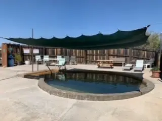
San Francisco Hot Springs
100–120°F
Pool temperatures
1.3mi
Hike, one way
Free
No fee reported
Short canyon hike on Trail 250 to a few primitive pools on the west bank of the San Francisco River. Only the Middle and Lower groups on national forest land are open to the public, and reaching them requires wading the river. Water runs about 100 to 120 F and clothing is commonly optional.
01 · Before you go
Plan your visit
What to expect on the ground: rules, facilities and when to go.
- Dogs allowed
- Clothing optionalCommon here, not official policy
- Camping nearbyOvernight parking and dispersed camping at the trailhead only, not at the springs.
- Toilets & parking
- PoolsA few pools in the Middle and Lower groups
- ModerateLow-water seasons when the river is easy to cross; avoid spring snowmelt and after storms.
- HoursTrailhead use dawn to dusk, overnight parking allowed.
- SeasonRiver crossing can be ankle-deep when dry but waist-deep or higher during snowmelt or after rain.
- Free to soakNo pass required. Permits are needed only for commercial or organized use.
Best time to go. Low-water seasons when the river is easy to cross; avoid spring snowmelt and after storms.
02 · Live
Conditions
Access status, weather and hazards. Closure feeds are checked automatically every morning.
Access
No closures reported
No closure, fire or weather warning found in Forest Service, wildfire (NIFC) or National Weather Service feeds. That isn't confirmation it's open, so check with Gila National Forest.
Checked 22 Oct · updated daily
Gila National Forest Stage 1 fire restrictions began March 23, 2026; a later report says they were rescinded after rain, though the exact date was not found. No closure of the springs found in searches run October 18, 2026. The upper group is private (Sundial Springs) and closed to the public.
River crossing, with no crossing if water is turbid or fast. Very hot water near sources, no cell service in the canyon, untreated water needs filtering.
Get closure news by email
New closures, reopenings and new states, about once a month. No spam.
03 · Route
Getting there
Nearest town: Pleasanton. Then a 1.3-mile hike, one way.
- 1
From US 180 between mileposts 58 and 59, about 7 miles south of Glenwood and near Pleasanton, turn west onto Catron County Road C-025 and follow gravel about half a mile to the trailhead.
- 2
Trail 250 runs 1.25 miles to the San Francisco River, then cross the river to reach the Middle and Lower groups.
33.2440, −108.8800 · nearest town Pleasanton, NM
These coordinates are for the spring itself, not the parking area. Navigate to the trailhead named in the directions.
04 · Where to stay
Stay nearby
Start early and stay close. Places to stay near Pleasanton, from campgrounds to cabins.
If you book through these links we may earn a small commission, at no extra cost to you. It never affects what we list or how.
Checked against 5 sources, with closures, wildfires and weather warnings re-checked daily.Show sourcesShare your photosSuggest an update
- fs.usda.gov (trail, access, hours, permits, upper group private)
- hotspringsguides.com (temps, clothing, dogs, hazards, camping)
- stavislost.com (river crossing, trip report 2018)
- newmexico.org (location)
- nmfireinfo.com (fire restrictions 2026)